Groundwater QuantityGroundwater cannot be described by sub-watershed boundaries, as it does not respect these topographically defined areas. Rather, groundwater is placed in western and eastern groupings of sub-watersheds. In general, the western grouping has a shortage of high-yield freshwater aquifers. High-yield aquifers are typically associated with permeable sand and gravel deposits in the surficial geology, which allows groundwater to flow at significant rates. Groundwater resources in the eastern grouping appear to be abundant, but mapping this area is challenging. The Mighty Peace watershed has less groundwater monitoring information available compared with the province's southern watersheds, such as the Bow River and Oldman River watersheds. But the water resource issues facing the watershed are also less urgent. Currently, the most comprehensive regional groundwater-monitoring program in place is ESRD's Groundwater Observation Well Network (GOWN). Twelve groundwater observation wells are active within the watershed, the majority of them located near Grande Prairie and the town of Peace River. Water levels in the Grimshaw Gravels aquifer can change by about a metre following changes in precipitation and in the levels of Lac Cardinal. Because it is shallow, there is strong interaction between water in the aquifer, precipitation, and Lac Cardinal levels. Despite the aquifer's changing levels, supply from this aquifer continues to be good, and no long-term decline is apparent.
MORE ABOUT THE GROUNDWATER OBSERVATION WELL NETWORK
is available online at: www.alberta.ca/lookup/groundwater-observation-well-network.aspx
|
Groundwater Observation Well Network Locations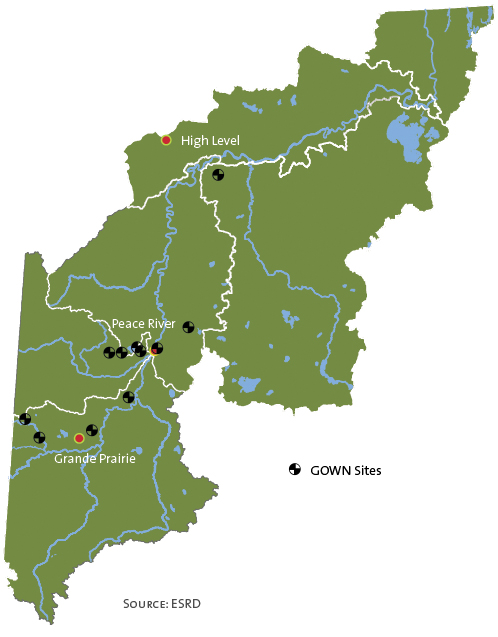
Source:ESRD
WHAT IS AN AQUIFER?
An aquifer is a water-bearing geologic unit below the groundwater table. Although most of these locations are fully saturated with water, only those with materials permeable enough to allow groundwater to flow at a significant rate are considered an aquifer. Because of these properties, aquifers can be important sources of water. Loosely stacked, non-consolidated, course-grained materials (such as sand and gravel) are the most common aquifer-forming mediums. Aquifers are often classified as surficial (shallow) and bedrock (deep). Surficial aquifers are a source of freshwater for drinking and agricultural uses. Bedrock aquifers often contain saline and brackish water used mainly for industrial purposes. The upper boundary of an unconfined aquifer is the water table, and confined aquifers have little if any connection to the water table. |
| © 2015 Mighty Peace Watershed Alliance | CONTACT THE ALLIANCE |
NEXT PAGE: Cadinal River/Grimshaw Aquifer |