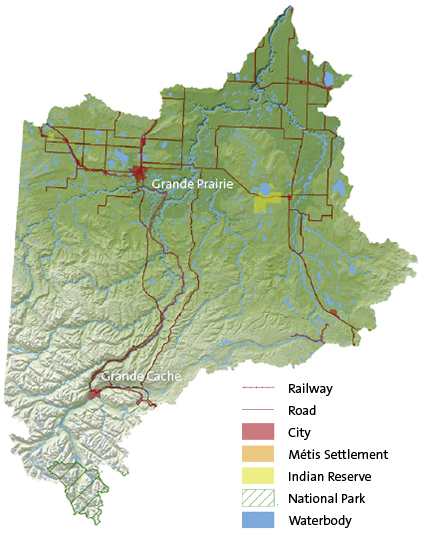
| | Smoky/Wapiti Sub-watershed
|
Demographics |
% of Mighty Peace
|
|
Area
|
46,659 m2
|
22 %
|
|
Population
|
101, 585
|
62 %
|
|
|
|
|
Where People Live
|
|
|
City
|
55,032
|
54 %
|
|
Towns
|
17,465
|
17 %
|
|
Rural
|
27,500
|
27 %
|
|
Metis Settlement
|
|
|
|
Reserve
|
1,588
|
2 %
|
| Surface Water Allocation (m3)
|
Groundwater Allocation (m3)
|
|
Total Volume
|
109,628,821
|
|
|
Total Volume |
10,476,478
|
|
|
Agricultural
|
2,267,422
|
2.07%
|
|
Agricultural
|
769,565
|
7.35%
|
|
Industrial
|
17,151,083
|
15.64%
|
|
Industrial
|
4,004,941
|
38.23%
|
|
Municipal
|
25,060,097
|
22.86%
|
|
Municipal
|
2,706,091
|
25.83%
|
|
Commercial
|
48,948,271
|
44.65%
|
|
Commercial
|
1,244,668
|
11.88%
|
|
Watershed Management
|
10,327,940
|
9.42%
|
|
Other
|
523,372
|
5.00%
|
|
Habitat Enhancement
|
4,426,665
|
4.04%
|
|
Recreation
|
29,230
|
0.28%
|
|
Registration
|
1,266,823
|
1.16%
|
|
Registration
|
1,193,965
|
11.40%
|
|
Recreation
|
61,670
|
0.06%
|
|
Habitat Enhancement
|
4,648
|
0.04%
|
|
Other
|
94,900
|
0.09%
|
|
|
|
|
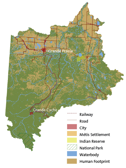
Footprint
|
Total Footprint |
29.91% |
|
Cultivation (Crop/Pasture/Bare Ground)
|
17.05%
|
|
Cut Blocks
|
9.29%
|
|
Seismic line
|
0.80%
|
|
Road – Vegetated Verge
|
0.56%
|
|
Pipeline
|
0.46%
|
|
Rural (Residential/Industrial)
|
0.39%
|
|
Well Site
|
0.37%
|
|
Road – Hard Surface
|
0.33%
|
|
Road/Trail (Vegetated)
|
0.27%
|
|
Transmission Line
|
0.07%
|
|
Urban
|
0.10%
|
|
Borrow-Pits/Dugouts/Sumps
|
0.04%
|
|
Mine Site
|
0.09%
|
|
Industrial Site Rural
|
0.03%
|
|
Other Disturbed Vegetation
|
0.03%
|
|
Rail – Vegetated Verge
|
0.02%
|
|
Rail – Hard Surface
|
0.01%
|
|
Undisturbed |
70.09%
|
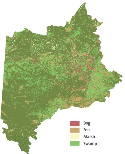
Wetland Cover (outside of national parks)
|
11%
|
5,198 km2
|
|
Wetland type within sub-watershed
|
|
Bog
|
11%
|
572 km2
|
|
Fen
|
28%
|
1,475
|
|
Marsh
|
4%
|
198
|
|
Swamp
|
57%
|
2,953
|
| |
|
|