Flow, Weather and Climate | ||||
| Sudden changes in water level in rivers and lakes can occur because of rainfall, seasonal snow melt and periods of drought. The largest seasonal fluctuation occurs during the spring snow melt when large volumes of meltwater fill the rivers and lakes in the watershed. Gradual changes in the amount of surface water can be attributed to a changing climate as well as the effect of human activities, or a combination of the two. |
There is also a connection between surface water and groundwater quantities. For example, a drop in the groundwater table or water level in surficial aquifers can affect lake and river water levels. How quickly this happens depends upon how porous the ground is in the area. |
|||
Long-term Water Quantity in the Peace River and Its TributariesThe Peace River flows at Dunvegan (above the confluence with the Smoky River) show a change following dam commissioning in 1968.Otherwise, there is no long-term change in Peace River flows.24 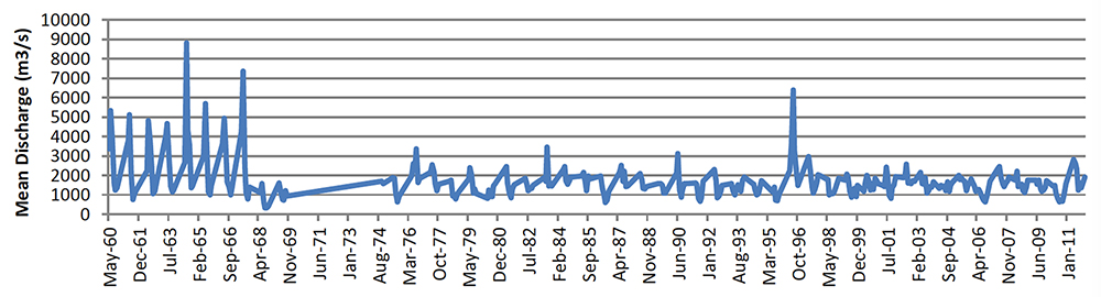 Water supply in most tributaries does not generally appear to have changed over the past 40 years. However, formal trend analyses should be completed on streamflow and lake-water levels in the watershed. For instance, water quantity in the Wabasca River appears to have dropped since 2000 (see chart below). A trend analysis could be used to identify the causes of the trend, and what consequences a trend could have for management actions. Existing technology can be used to conduct these analyses rapidly on an annual basis. |
||||
| © 2015 Mighty Peace Watershed Alliance | CONTACT THE ALLIANCE |
NEXT PAGE: Historical Discharge |